Saturday, December 13, 2014

The Saga of LaSalle Street Station


The two principal owners of LaSalle Street Station.

In 1851 the Chicago and Rock Island Railroad incorporated and began construction of a line between Chicago and Joliet, which was completed in 1852.  That same year the Northern Indiana and Chicago Railroad reached Chicago, the first Eastern railroad to reach the city.


 This 1862 map shows the first station.

The first LaSalle Street station was constructed at the foot of Van Buren Street at LaSalle Street and opened on May 22, 1852 coinciding with the completion of the Northern Indiana and Chicago. The Rock Island began using the station soon after on October 1, 1852. The NI&C would later become the Lake Shore and Michigan Southern Railway (LS&MS), a subsidiary of the New York Central Railroad, and the Chicago, Rock Island and Pacific Railroad (CRI&P). Both companies shared a right-of-way to the terminal north of their intersection at Junction Grove, later known as Englewood.  There appears to be no illustrations or photographs of the first station, although it does appear on early maps.  It was probably a humble structure made of wood, similar to other early railroad stations in the city’s central business district.  With the rapid growth of passenger traffic a larger station was called for, and construction of the new building began on April 16th of 1866.

 
 Architect Boyington and his masterwork.
 
Completed in November of 1866, it was designed by architect W.W. Boyington. Boyington is best known as the architect of the iconic Chicago Water Tower. Designed in the “Franco-Italian” style, the station building measured 542 feet by 160 feet.  The balloon type train shed roof spanned five tracks, three tracks for departing trains and two for trains arriving. The Howe Truss roof stood 60 feet above the platforms and was covered with slate. The west side of the building contained a number of rooms for the accommodations of travelers waiting for the departure of trains. These rooms connected with the platform within the depot, and fronted on Sherman and Griswold streets. Each railroad using the depot had baggage rooms, oil and lamp rooms, conductors’ room, and large waiting “apartments” for ladies and gentlemen. There were rooms for second class passengers and immigrants, as well as a restaurant and ladies dining room.  The Van Buren Street facade featured a frescoed entrance hall. On the east side of this hall were the offices of the Michigan Southern and Northern Indiana Railroad Company. On the west side of the hall were the offices of the Chicago, Rock Island and Pacific Railroad.


The fire ravaged remnants of the station.
 
The Great Chicago Fire of October 1871 destroyed the station, which was rebuilt and expanded with additional stories shortly afterwards. From its completion in 1882, the New York, Chicago and St. Louis Railroad (Nickel Plate Road) ran over the Lake Shore and Michigan Southern Railway from a junction at Grand Crossing neighborhood north to downtown Chicago, where it had its own terminal south of LaSalle Street Station at 12th Street. The LS&MS quickly gained control of the Nickel Plate, and later allowed it into its LaSalle Street Station as a tenant. The station was also served by a direct link to the elevated rapid transit system.

The rebuilt and expanded station.

The direct connection with the elevated train was a major advertising point.
 
On December 20th 1901 the trains using the station were shifted over to Grand Central Station and the post-fire station was demolished to make way for a new station designed by the architectural firm of Frost and Granger. The initial plans called for an 8-story steel-framed office building with a station on the first three levels. By the time construction started an additional 4 stories were added.  The construction of the station coincided with the raising of the platform tracks above street level.  The station design included a massive balloon shed covering eleven tracks.  The limestone facade of the old station was ground up and used in the concrete for the foundation of the new station.  The station opened for business in May 1903, and cost close to $2,000,000.

Plaster model of the station's initial design.

 
Construction photographs.

Postcard images and photographs of the station's exterior.

Photographs of the station's interior.
 
Among the most famous name trains that terminated at LaSalle were the New York Central's 20th Century Limited from 1902 until 1967 and the Rock Island-Southern Pacific Golden State Limited from 1902 until 1968.  Most intercity rail service at La Salle ended on May 1, 1971 when Amtrak consolidated long-distance services at Union Station. Rock Island opted out of Amtrak and continued to operate intercity service from LaSalle until 1978. The station was a set for Alfred Hitchcock's 1959 North by Northwest, starring Cary Grant and Eva Marie Saint, and in the 1973 movie The Sting starring Paul Newman and Robert Redford.

 
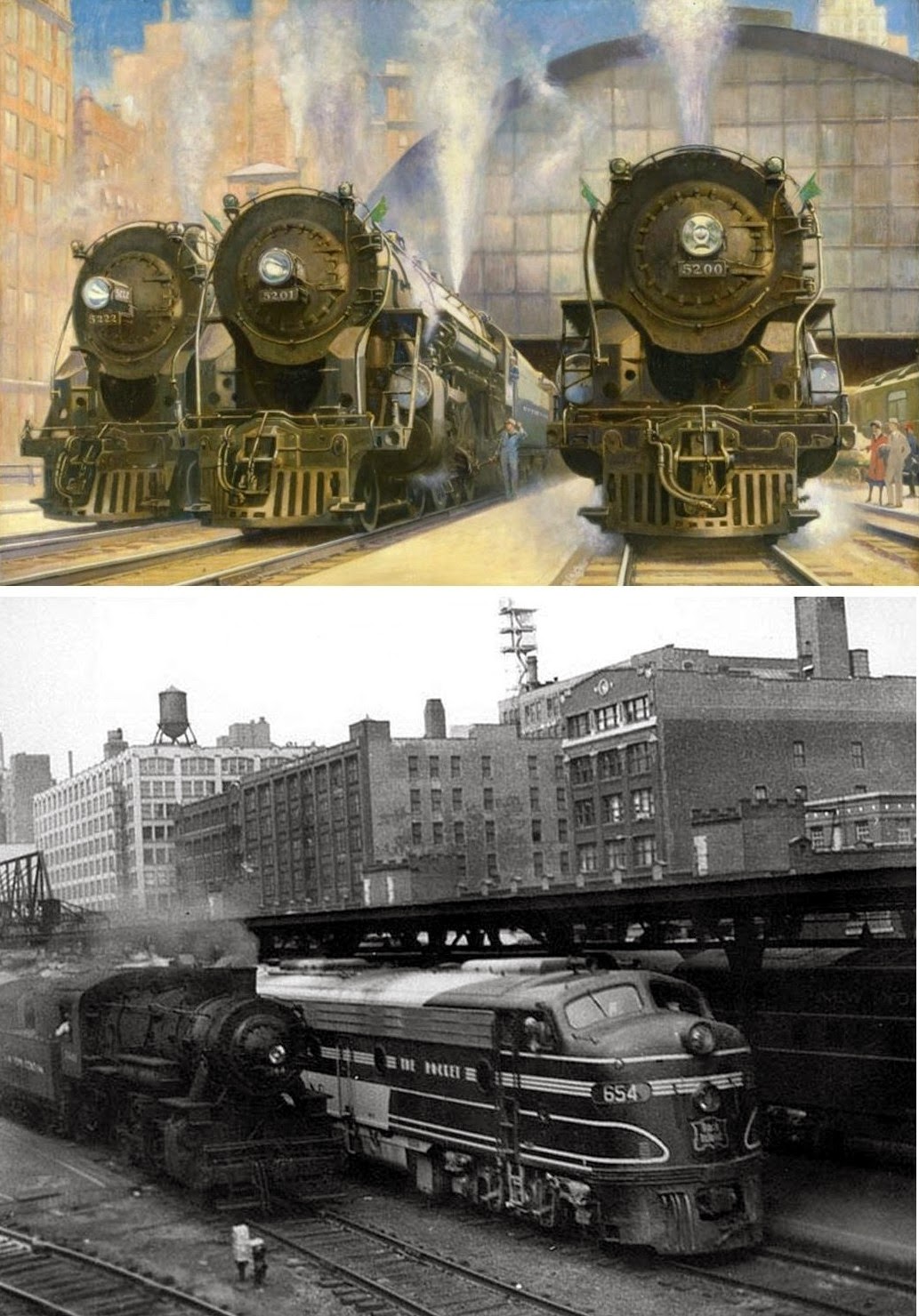
The New York Central's and Rock Island's crack passenger trains operated out of the station.
  
The Rock Island fell on hard times in the 1960’s and filed for bankruptcy on March 17, 1975, and the station continued to serve as a commuter terminal while the bankruptcy wound its way through the courts.  The plight of the Rock and other commuter services was impetus for the formation of the Regional Transportation Authority in 1974.  In 1980 the bankruptcy judge liquidated the assets of the railroad, completely ending operations on March 31, 1980.  The RTA purchased the commuter service that did not include the station, which had become decrepit after years of deferred maintenance.  In 1984 the RTA created Metra as the operating agency for Chicago’s regional commuter railroad service.

 
By the time the RTA assumed commuter operations the station had become decrepit.

The Chicago Pacific Corporation, a shell corporation, was created from the remains of the railroad to sell off its assets including the station. The station was then sold to the Chicago Board of Options Exchange who demolished it in 1981 and replaced it with a new office tower and trading floor.  This essentially severed the former station's link with Van Buren Street and pushed  the platforms south of Congress Parkway.  Exit from the station is now accomplished by two narrow enclosed corridors on the LaSalle Street and Financial Place sides of the new building.  A small “station” was added to the building in 1984.

 
LaSalle Street Station was replaced by One Financial Place.

In 1985 the Chicago Pacific Corp. announced plans with other landholders to develop 150 acres in the area that would require the station to be moved two more blocks south and a block east.  Other plans called for Metra to move the Rock Island service to Union Station to accommodate the development plans.  Yet another plan called for the tracks to be depressed below grade along with the platforms and waiting room. Competing studies weighed the merits of these plans, but Metra and the RTA balked and brought public and political pressure on the developers to abandon their plans. Metra’s plans for an improvement project to rehabilitate the platforms were stymied by this battle.  After two years Metra won its battle and the tracks and platforms remained.


 Metra's present day LaSalle Street Station.
 
Viewed from today’s perspective the continued presence of the tracks has not been a hindrance to development in the area.  The plan to move the trains to Union Station would have proved to have been a transit nightmare as Union Station is now at capacity.  Although only Metra's Rock Island District trains now use LaSalle, additional service is planned. Metra's proposed Southeast Service would terminate at LaSalle, and Chicago's massive CREATE infrastructure improvement program would allow trains from Metra's Southwest Service to use the terminal.  In June 2011, The Chicago Department of Transportation opened the LaSalle/Congress Intermodal Transfer Center alongside the station as a bus terminal to serve people transferring to CTA buses as well as Blue Line trains at LaSalle.


 The Chicago Transit Authority's Intermodal Transfer Center.
 
The final lesson in the history of LaSalle Street Station is the failure to incorporate a new station into the Board of Options Building.  Commuters became an afterthought rather than an asset.  When the Chicago & North Western Madison Street Station was demolished it was replaced by an office building that included a train station.  The station is filled with the kind of shops and restaurants that one would expect in a modern urban transportation center.  As it stands now the present LaSalle Street Station is little more than a cattle trough with a miniscule waiting room.  At best it’s a monument to missed opportunities to create a transportation nexus worthy of its predecessors.

 
 Development continues to take place despite the presence of the tracks to LaSalle Street Station.

Sunday, November 2, 2014

The Chicago Railroad Fair


In 1948 and 1949 America's Railroads celebrated the 100th Anniversary of the first train to operate in Chicago with a grand public exhibition of their history and progress.  The Chicago Railroad Fair represented a remarkable cooperative effort among the nation's railroads to depict the role of Chicago as the epicenter of the American railroad industry.  Through an amazing display of equipment including more than 30 locomotives, as well as a daily pageant depicting the history of America's railroads, the public was given glimpse into the past, present and future of the rail industry.
 
Locomotive "Pioneer" Arrives at the Railroad Fair

The initial idea for the Fair was conceived by Francis V. Koval, the publicity manager for the Chicago & North Western Railroad, as a commemoration of the 100th anniversary of the first train to operate in Chicago in 1848.  Koval imposed upon the Chicago Tribune to host a dinner for the various railroad presidents where the idea of a centennial celebration was presented.  The Fair developed from that dinner meeting.

Major Lenox R. Lohr

The president the National Broadcasting Company and Museum of Science and Industry, Major Lenox R. Lohr, was elected president of the event.  Lohr was a master a bringing together the various elements that were required for a successful event, with previous experience as business manager of the Century of Progress.  Historian Ed Hungerford was hired to write the pageant script while the official song of the fair, "Wheels a-Rolling", was penned by Evanstonians Mr. and Mrs. Phillip Maxwell.

Sheet music for the Wheels a-Rolling theme song

 Past meets the present at the Fair
"The General", made famous by the Civil War chase

37 American railroads served as sponsors, subscribing $1.25 million to the effort.  Additionally many lines provided rare equipment for display such as the "Stoubridge Lion" of 1829, the B&O's "William Mason", the famous Civil War locomotive "The General" as well as the C&NW's own "Pioneer" locomotive.  The public was treated to a plethora of mighty modern steam locomotives as well as General Motors FT diesel locomotive that would radically change the railroad industry.

The grand parade on State Street

The opening of the Fair was preceded by a gala parade held on July 19, 1948.  Starting at Columbus Drive in Grant Park at 1:30 PM, the parade traveled up Jackson Boulevard to State Street then north to Wacker Drive.  The widow of Casey Jones rode in an automobile at the head of the parade followed by floats, replica locomotives and a military contingent of Army, Navy, Marine and National Guard soldiers and sailors.

The main entrance of the Fair

The official opening of the fair began with a flag raising at 10 am on July 20th at the Fair's main entrance at 23rd Street, with Major Lohr presiding.  The fair covered 50 acres between 20th and 30th Street, taking advantage of the abandoned fairgrounds from the Century of Progress Fair of 1933.  Parking was provided for 1,800 automobiles, which represented an ironic bow to a form of transportation that would effectively destroy rail passenger service.

Recreation of the Golden Spike at the Wheels a-Rolling pageant

Admission to the Fair was 25 cents, and another 60 cents for a ticket to the gala "Wheels a-Rolling" pageant.  A narrow gauge train ride around the Fair cost 10 cents.  The pageant consisted of 12 scenes, along with a prologue and epilogue, telling the dramatic story of America's rise from wilderness to mighty industrial nation victorious in war.  Presented in an outdoor theater seating 6000 with Lake Michigan as the backdrop, 4 daily shows of one-and-a-quarter hours presented this grand story to millions of attendees.

Union Pacific EMD F3 diesel electric locomotive on display

At least 18 locomotives operated under their own power along with 220 performers with 18 different period costumes.  Horse and motor driven vehicles were also included.  30 additional locomotives and pieces of equipment were part of the general exhibition outside the theater.

Passengers climb onto a San Francisco cable car.
At one time Chicago had the largest cable car system in the country.

Visitors could ride an authentic San Francisco cable car, see American Indians perform at Santa Fe's Indian village, see a rodeo or visit "Florida in Chicago" compliments of the Chicago & Eastern Illinois Railroad.

 American Indians perform native dances at the Fair


The Fair proved so popular it was reprised in 1949, and represented a sort of last public hurrah by the rail industry.  The Second World War saw America's railroads perform a stellar job of moving freight and passengers under great duress.  Wartime restrictions on modernization had placed the railroads in a poor competitive position to deal with the rise of the automobile, airline and trucking industries.  By the 1950's the creation of the interstate highway system and the continued application of restrictive regulations on railroads would further drive the nation's railroads to near ruin.  The Fair coincided with Chicago reaching an apex of rail freight and passenger traffic that would slowly diminish over the ensuing decades.  It was Chicago's and the railroad industry's moment in the sun that would all too quickly be eclipsed.


Monday, July 7, 2014

The Air Line Without Airplanes

Early Railroad Survey Crew

While we are accustomed to thinking of an airline in terms of aviation travel, it was originally used by surveyors as a common term for the shortest distance between two points.  In the 19th Century a number of railroads used "air line" in their title to suggest their routes were shorter than competing railroads.

Map of tracks including the St. Charles Air Line

The Chicago, St. Charles and Mississippi Air Line was chartered in 1852, with a planned route from Chicago to the Mississippi River at Savanna, IL via St. Charles, IL.  The Chicago terminus and depot would have been located at the northeast corner of Stewart Ave. and 16th Street.  The line was intended to compete with the Galena and Chicago Union Railroad (G&CU), chartered in 1836 and completed in 1853.  The GC&U opposed the project and chartered their own competing line, the Dixon Air Line Railroad, from St. Charles to Dixon, IL.

Railroad grain elevators at the mouth of the Chicago River

This planned line was reorganized as a jointly owned, unincorporated project known as the St. Charles Air Line (SCAL).  This truncated version began at the Illinois Central (IC) on Chicago's lakefront near 14th Street, and continued west along it's originally planned alignment to Western Ave.  A connection was built to the G&CU at this location, and completed in 1856.  The west end of the jointly owned trackage was actually the west bank of the Chicago River, somewhat short of the original destination of the Mississippi River.

 The first Central Station

The Chicago, Burlington and Quincy Railroad (CB&Q) was the next line to enter the picture, connecting with the SCAL at Western Ave.  The CB&Q would use this track to access the IC's original Central Station located near Randolph Street and the lake.  A planned alignment west of Western Ave. was used by the Chicago and Northern Pacific Railroad (C&NP), and would later become the Altenheim Subdistrict of the Baltimore and Ohio Railroad (B&O). This line was also used by the Chicago and Great Western Railroad and the Soo Line (formerly Wisconsin Central). At this point we may need a score card to keep up with all the players in this game.

Eventually the line came under the equal control of four railroads: the IC, the Michigan Central (MC), the CB&Q and the Chicago and North Western (C&NW), successor to the G&CU.  Originally built at grade level with numerous street crossings, the tracks were elevated on fill in 1897.  On the east end of the SCAL the tracks formed a "wye" and curved north and south to connect with the IC.  The north connection allowed access to Central Station and the yards, warehouses, grain elevators and coal docks on the main branch of the Chicago River.  The south leg connected with the IC freight and passenger mainline.

 Elevation of the north leg of the IC wye


 Track elevation of the Air Line west of the Chicago River circa 1897

West of Clark St. and east of the South Branch of the Chicago River, the IC tracks crossed the Chicago Rock Island & Pacific at grade then branched south along the river and west along the Air Line.  The tracks then bridged those leading to Dearborn Station.  The line crossed the river and traveled over the tracks to Union Station on a long, concrete viaduct until it drops down to the elevated embankment.

Original swing bridge being raised as part of the track elevation project


Aeriel view of the lift bridges

The two Strauss lift bridges, one permanently raised the other still active, are designated Chicago landmarks.  The river crossing was formerly via a swing bridge, which was eliminated when the South Branch of the river was straightened.  One of the lift bridges was moved from it's former location, and shortened as part of this project.  The Baltimore and Ohio used the now out-of-service bridge to access Grand Central Station at Harrison and Wells Streets.  Construction of Grand Central was begun by the Wisconsin Central (later Soo Line), completed by the C&NP and came under control of the B&O in 1910.

 Grand Central Station

IC Central Station

Time has wrought some changes to the line.  The north leg of the IC wye was removed with the discontinuance of passenger trains and the demolition of the second Central Station in 1974.  That area has since become a thriving residential neighborhood of high rises, lofts and new town houses.  The demolition of Grand Central Station in 1971 ended the need for the active use of the northern lift bridge, and it was permanently raised.  The tangle of interconnecting tracks east of the river has been greatly simplified with the demise of individual railroad passenger trains and their consolidation under Amtrak at Union Station.  The Air Line is still used by freight and passenger trains coming off the IC, now owned by the Canadian National Railroad (CN).  Metra, the commuter rail service, also uses it to move equipment from their shops at Roosevelt and Canal to the Rock Island District commuter line.  In the arcane world of railroading, the lift bridge operator is often referred to as the "B&O Operator"; and is an employee of the CSX Railroad, successor to the B&O.


 A 1920's view of the St. Charles Air Line on the right as it crosses Canal Street

 Metra switch engine crosses over Canal Street on the Air Line

The SCAL has become a controversial element of the urban fabric with the transformation of the former IC property, and the surrounding area formerly used for warehouses and light industry, to pricey residential living.  The new residents find the presence of trains transversing their neighborhood to be a source of irritation and annoyance.  Believing the promises of real estate agents that, "not too many trains come through here" and "they're removing the tracks very soon" these residents cannot understand why there is no forthcoming solution to their dilemma.  While plans have been made to eliminate the SCAL, there is little in the way of public funds available to create the necessary rail connections in other locations to accomplish this.  The railroad affected by this potential change, the CN, will not fund the project by themselves.  Amtrak also relies on the line to bring it's trains on and off the CN to Union Station.


 Amtrak train passes a loft conversion of an old warehouse

For the foreseeable future, the Air Line without airplanes will continue to be a presence in Chicago's railroad environment.

Thursday, April 10, 2014

The Lakefront Railroad


The Illinois Central Railroad is entwined in Chicago's history, particularly the eventual shape of the downtown lakefront.  A Senate bill sponsored by Stephen A. Douglas would create a railroad funded through the sale 11,500,000 acres of public land in the state.  The railroad would sell the lands granted to it as financing for its construction.  Signed in 1850 by President Millard Fillmore, the act called for construction of a railroad from the junction of the Ohio and Mississippi Rivers to the western end of the Illinois & Michigan Canal at Peru or LaSalle.  Two branches from that point would lead to Dubuque, Iowa and Chicago.  At 705 miles, the charter would create a railroad twice as long as any other in the country.

When the Chicago branch was planned it was 200 mile route was in a virtually straight line from Effingham County to the southern border of Cook County at Richton.  A route to Chicago was planned around the western shore of Lake Calumet then north to the dock facilities on the Chicago River.  In the meantime a fight had broken out between rival railroads Michigan Southern and Michigan Central who were trying to extend into Chicago from the east.  As there were no provisions for granting out-of-state railroads operating charters each road joined forces with an existing railroad; The MIchigan Southern and the Rock Island and the Michigan Central and the IC.  The construction race was on, and the Rock Island trumped the IC by obtaining much of the route they had planned on using.  The MC and RI reached the city on February 20, 1852.

The IC was not to be deterred and began looking for a suitable alternative.  This route eventually brought the railroad along the lakefront to the city limits, then at 23rd Street.  The next step was access to the downtown itself.  The route along the lakefront would not be popular amongst citizens and politicians, but in 1852 the railroad was the solution to a persistent problem of lake storms washing away the shoreline along Michigan Avenue.  The railroad would build and maintain break walls and dikes to protect their tracks, and in turn protect the shoreline.  On June 14, 1852 an ordinance was passed, granting the IC a 300 foot right-of-way to construct the necessary landfill and trestles.

Michigan Ave. looking north.

 IC lakefront trackage looking south from near Randolph Street.

 IC's first passenger station with elevators in the background.

 Map of IC's riverfront facilities.

At the time of construction Michigan Avenue was lined with the mansions of wealthy citizens, and the IC was forbidden from erecting structures between Randolph Street and Park Row (12th Street).  To compensate for this the IC bought up large tracts of land at Randolph Street near the mouth of the Chicago River, and constructed a passenger station, yards and grain elevators.  Further south the ever astute Sen. Douglas purchased 6,000 acres of swampy land near Lake Calumet.  This area would eventually become home to steel mills and numerous industries, including the Pullman Palace Car Company.

Lake Front Park later renamed Grant Park

The next great change to the lakefront was the Great Fire of 1871.  Debris from the fire was used to fill in the area between Michigan Avenue and the IC tracks, which eventually became known as Lake Front Park.  The IC's station and freight structures were destroyed by the fire.  Enough of the station walls were left standing to incorporate them into a new structure.  With the coming of the World's Fair in 1893 the IC was confronted with a traffic dilemma.  Being the only railroad with a direct route into the fairgrounds meant it would handle a larger volume of passengers than ever before.  The IC already had a robust commuter service that began in 1856.  A new main passenger terminal was built at Park Place (12th Street) and commuter service was beefed up with new cars and locomotives.

IC Central Station, Cass Gilbert architect.  Photo circa 1893.

Below grade track depression at 11th Place

Electric cars replace steam locomotives in 1926

The next big change for the lakefront was the depression of the tracks below street grade between 47th Street and Randolph Street as part of Chicago's track separation ordinances in 1909 and the lakefront smoke abatement ordinance of 1919.  The latter forced the IC to electrify their commuter and lakefront freight yards.  While the commuter service was completely electrified, the freight electrification was short lived due to the introduction of diesel locomotives.  The downtown Congress Street yard was the location of the IC's high speed produce service, and was part of a larger complex known as the South Water Street Market.  The city would relocate the market to modern facilities and for a while the land became a sea of surface parking.

 South Water Market (left).  Surface automobile parking on the site of the old yard (right).

 Prudential Towers (left).  Illinois Center (right).

 Millennium Park

Lake Front Park, now known as Grant Park, was expanded east of the tracks with additional landfill as part of the Burnham Plan of Chicago.  Air rights development over IC land began in 1955 with the completion of the Prudential Building.  The IC itself located its headquarters in the Illinois Center complex following demolition of Central Station.  An area that had once been covered with freight yards, warehouses and grain elevators is now home to tony condos and high rise office buildings.  To the south, Millennium Park and its iconic 'Bean' sculpture now rest over some of the existing suburban tracks.  The demolition of the Central passenger station and removal of the tracks opened land for a residential development known as Central Station.

 Central Station residential development on the site of the IC Central Station (demolished).

The railroad that helped make Chicago and define its lakefront has faded into history, merged into the Canadian National Railroad.  On its old bones, new developments have blossomed that are remaking the city.  The electric commuter trains still run every day, now under the operation of Metra, the commuter rail agency.

                     Metra Electric train pulls into Van Buren Street Station, a remnant of the track depression project.  Photo credit Jim Watkins